Ganga-Padma Master Plan to check erosion
The Bengal government is preparing a master plan to control erosion along the banks of the Ganga, including on the border with Bangladesh, which would give respite to lakhs of residents of the districts of Malda and Murshidabad.
The Bengal government is preparing a Ganga-Padma Erosion Control Master Plan to check the erosion along the rivers Ganga and Padma.
The Ganga flows from Bihar into Bengal in Malda district and then runs along the border of Malda and Murshidabad. Its course then follows for a long distance along the border of Murshidabad with Bangladesh, to finally flow into the latter as Padma.
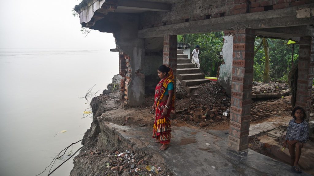
The erosion of the riverbank is a long-standing problem. Not only does it lead to annual floods causing huge losses to life and property but equally importantly, the erosion for many years now has been depleting the riverbank on the Indian side in Murshidabad and adding to the Bangladeshi side, thus causing loss of land (and along with it, livelihoods) for India.
The move for the master plan was taken after an eight-point charter of demands was submitted by the state government before the Union government and NITI Aayog, claiming for a comprehensive resolution to flooding and erosion in Bengal.
It may be mentioned in this connection that another major flood control project, the Ghatal Master Plan in West Midnapore district, has been hanging fire for some years now because of the Union government’s unwilling to give its share of the money (after much delay, to complete it quickly, the state government had even increased its share from 25 per cent to 50 per cent, and has allocated the entire money as well, but the Centre is dithering with paying even that 50 per cent of the cost).
Sources said the work to prepare the master plan has been initiated and a detailed project report (DPR) would be sent to the concerned Union ministry.
On the state’s side, the Irrigation and Waterways Department (I&WD) is handling the project. The department’s River Research Institute has initiated a survey using acoustic doppler current profiler (ADCP) technology to measure the rate of depletion of land. Senior officials and engineers of the department have also initiated site visits to identify the vulnerable areas.
Meanwhile, massive erosion has reduced the distance between the rivers Ganga and Fulahar from 8 km eight years ago to only 1.6 km now. An assessment of the I&WD has revealed that even the 1.6 km land between the rivers would get washed away in the next six to seven years if immediate steps are not taken.
The Ganga-Padma Erosion Control Master Plan, when completed, will give a respite to lakhs of residents, mainly of Malda and Murshidabad districts, from the menace of acres after acres getting washed away due to erosion every year.